


city

icone_mesure
slug
city

Measurement_a73cd064-e441-4170-ba72-8c094f3565dc

Measured radiation

0.350 µSv/h
geolocalisation :

47.7436, -2.68054

Ground level
Iron Kloug
ATYPICAL MEASURE
Date de la mesure :
Latitude :
47.7436
Longitude :
-2.68054
Altitude (M) :
90.0
Measurement time :
5 minutes
Distance travelled :
Measurement speed :
Measurement Environment :
En ville city
Weather :
Tags :
Description :
gite
27.7 c/s sur 300 secondes
Temperature :
12.0°C
Hits number :
8310
Mesure UUID :
a73cd064-e441-4170-ba72-8c094f3565dc
Manual Reporting :
Yes
Sensor / ID :
Sensor / Firmware version :
Sensor / Type :
Sensor / Tube type :
Smartphone / UUID :
Smartphone / Platform :
Smartphone / Model :
Smartphone / OS Version :
Position acurracy :
Measurement height above the ground (in meters) :
Altitude accuracy :
Mean qualification :
Ground level
Software version :
openradiation.org v1
Measured value :
0.350 µSv/h
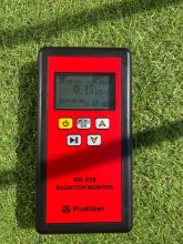
Measurement_ffbd6db8-3220-4218-a851-151764825111

Measured radiation

4.841 µSv/h
geolocalisation :

48.834943333333, 2.5796233333333

Ground level
MIRAGE-77
ATYPICAL MEASURE
Date de la mesure :
Latitude :
48.834943333333
Longitude :
2.5796233333333
Altitude (M) :
49.0
Measurement time :
1 minutes 1 secondes
Distance travelled :
924.13m
Measurement speed :
Measurement Environment :
En ville city
Weather :
Tags :
Description :
Temperature :
Hits number :
1617
Mesure UUID :
ffbd6db8-3220-4218-a851-151764825111
Manual Reporting :
No
Sensor / ID :
safecast_id 1223
Sensor / Firmware version :
$BNRDD
Sensor / Type :
Sensor / Tube type :
Smartphone / UUID :
Smartphone / Platform :
Smartphone / Model :
Smartphone / OS Version :
Position acurracy :
5.0
Measurement height above the ground (in meters) :
1.00
Altitude accuracy :
5.0
Mean qualification :
Ground level
Software version :
openradiation.net/upload v0.9
Measured value :
4.841 µSv/h

Measurement_faa3be46-99f5-4fcc-b39f-8d8411e41dfb

Measured radiation

0.150 µSv/h
geolocalisation :

45.746186987665, 4.8661140316847

Ground level
Gcsy
Date de la mesure :
Latitude :
45.746186987665
Longitude :
4.8661140316847
Altitude (M) :
173.0
Measurement time :
1 minutes
Distance travelled :
0.00m
Measurement speed :
Measurement Environment :
En ville city
Weather :
Tags :
Description :
radiation d’ambiance
measurment image
Temperature :
17.0°C
Hits number :
Mesure UUID :
faa3be46-99f5-4fcc-b39f-8d8411e41dfb
Manual Reporting :
Yes
Sensor / ID :
Sensor / Firmware version :
Sensor / Type :
Sensor / Tube type :
Smartphone / UUID :
DAAA0BDC-91A5-4444-A7A4-CDF85DF02A5D
Smartphone / Platform :
iOS
Smartphone / Model :
iPhone12,8
Smartphone / OS Version :
15.3.1
Position acurracy :
19.0
Measurement height above the ground (in meters) :
1.00
Altitude accuracy :
19.0
Mean qualification :
Ground level
Software version :
OpenRadiation app 2.3.4
Measured value :
0.150 µSv/h

Measurement_72d2f48b-b115-4ea3-844e-d68e79a44892

Measured radiation

0.176 µSv/h
geolocalisation :

47.2340011, -1.5646541

Ground level
Alpharty
Date de la mesure :
Latitude :
47.2340011
Longitude :
-1.5646541
Altitude (M) :
75.0
Measurement time :
1 minutes 49 secondes
Distance travelled :
125.39m
Measurement speed :
Measurement Environment :
En ville city
Weather :
Tags :
Description :
Temperature :
15.0°C
Hits number :
51
Mesure UUID :
72d2f48b-b115-4ea3-844e-d68e79a44892
Manual Reporting :
No
Sensor / ID :
80:30:DC:4A:BB:9D
Sensor / Firmware version :
AtomTag v.1.0.3
Sensor / Type :
Sensor / Tube type :
SBM-20
Smartphone / UUID :
63eb68845b623e5e
Smartphone / Platform :
Android
Smartphone / Model :
SM-G930F
Smartphone / OS Version :
8.0.0
Position acurracy :
7.7
Measurement height above the ground (in meters) :
1.00
Altitude accuracy :
7.7
Mean qualification :
Ground level
Software version :
OpenRadiation app 2.3.4
Measured value :
0.176 µSv/h

Measurement_68b9e3cd-4f0d-4f75-8f26-6892ecc7254f

Measured radiation

0.201 µSv/h
geolocalisation :

49.441576684364, 1.0915433782801

Ground level
REP-Rouen2023
ATYPICAL MEASURE
Date de la mesure :
Latitude :
49.441576684364
Longitude :
1.0915433782801
Altitude (M) :
10.0
Measurement time :
1 minutes 47 secondes
Distance travelled :
0.00m
Measurement speed :
Measurement Environment :
En ville city
Weather :
Tags :
Description :
Temperature :
29.0°C
Hits number :
51
Mesure UUID :
68b9e3cd-4f0d-4f75-8f26-6892ecc7254f
Manual Reporting :
No
Sensor / ID :
ca232330
Sensor / Firmware version :
RiumGM BLE -b
Sensor / Type :
Sensor / Tube type :
J305γβ
Smartphone / UUID :
099DFCB7-1478-4415-9D8B-B22AC1148A94
Smartphone / Platform :
iOS
Smartphone / Model :
iPhone9,3
Smartphone / OS Version :
15.7.2
Position acurracy :
32.0
Measurement height above the ground (in meters) :
1.00
Altitude accuracy :
32.0
Mean qualification :
Ground level
Software version :
OpenRadiation app 2.3.4
Measured value :
0.201 µSv/h

Measurement_ff4d3820-c2e6-493c-a201-081766901871

Measured radiation

0.195 µSv/h
geolocalisation :

45.94803, 4.7164416666667

Ground level
MIRAGE-77
Date de la mesure :
Latitude :
45.94803
Longitude :
4.7164416666667
Altitude (M) :
167.0
Measurement time :
1 minutes
Distance travelled :
2056.32m
Measurement speed :
Measurement Environment :
En ville city
Weather :
Tags :
Description :
Temperature :
Hits number :
65
Mesure UUID :
ff4d3820-c2e6-493c-a201-081766901871
Manual Reporting :
No
Sensor / ID :
safecast_id 1223
Sensor / Firmware version :
$BNRDD
Sensor / Type :
Sensor / Tube type :
Smartphone / UUID :
Smartphone / Platform :
Smartphone / Model :
Smartphone / OS Version :
Position acurracy :
8.0
Measurement height above the ground (in meters) :
1.00
Altitude accuracy :
8.0
Mean qualification :
Ground level
Software version :
openradiation.net/upload v0.9
Measured value :
0.195 µSv/h

Measurement_8ecbb44b-8b06-44a8-93b2-d73084c23826

Measured radiation

0.250 µSv/h
geolocalisation :

49.2432488, 6.1585645

Ground level
NicoLex
ATYPICAL MEASURE
Date de la mesure :
Latitude :
49.2432488
Longitude :
6.1585645
Altitude (M) :
216.0
Measurement time :
Distance travelled :
0.00m
Measurement speed :
Measurement Environment :
En ville city
Weather :
Tags :
Description :
a proximité d'une acierie
Temperature :
Hits number :
Mesure UUID :
8ecbb44b-8b06-44a8-93b2-d73084c23826
Manual Reporting :
Yes
Sensor / ID :
Sensor / Firmware version :
Sensor / Type :
Sensor / Tube type :
Smartphone / UUID :
96294b6a0cec6792
Smartphone / Platform :
android
Smartphone / Model :
M2101K7BNY
Smartphone / OS Version :
13
Position acurracy :
18.2
Measurement height above the ground (in meters) :
1.00
Altitude accuracy :
18.2
Mean qualification :
Ground level
Software version :
OpenRadiation app 3.1
Measured value :
0.250 µSv/h

Measurement_9bdf470c-a997-4fff-a538-ecca4fc19b38

Measured radiation

0.084 µSv/h
geolocalisation :

45.865352, -0.9645639

Ground level
ghis
Date de la mesure :
Latitude :
45.865352
Longitude :
-0.9645639
Altitude (M) :
62.0
Measurement time :
4 minutes 50 secondes
Distance travelled :
3.62m
Measurement speed :
Measurement Environment :
En ville city
Weather :
Tags :
Description :
Temperature :
28.0°C
Hits number :
69
Mesure UUID :
9bdf470c-a997-4fff-a538-ecca4fc19b38
Manual Reporting :
No
Sensor / ID :
e495aa31
Sensor / Firmware version :
RiumGM BLE -u
Sensor / Type :
Sensor / Tube type :
J305γβ
Smartphone / UUID :
d1e3d7eaec6a1c93
Smartphone / Platform :
Android
Smartphone / Model :
SM-A202F
Smartphone / OS Version :
9
Position acurracy :
2.5
Measurement height above the ground (in meters) :
1.00
Altitude accuracy :
2.5
Mean qualification :
Ground level
Software version :
OpenRadiation app 2.3.3
Measured value :
0.084 µSv/h

Measurement_34ec0e73-b23a-4db9-9798-3043b6c10a3a

Measured radiation

0.046 µSv/h
geolocalisation :

48.7884252, 2.2833536

Ground level
Fanche
Date de la mesure :
Latitude :
48.7884252
Longitude :
2.2833536
Altitude (M) :
162.0
Measurement time :
4 minutes 39 secondes
Distance travelled :
0.00m
Measurement speed :
Measurement Environment :
En ville city
Weather :
Tags :
Description :
Temperature :
13.0°C
Hits number :
52
Mesure UUID :
34ec0e73-b23a-4db9-9798-3043b6c10a3a
Manual Reporting :
No
Sensor / ID :
80:30:DC:4A:B7:65
Sensor / Firmware version :
AtomTag
Sensor / Type :
Sensor / Tube type :
SBM-20
Smartphone / UUID :
f15368685e92af51
Smartphone / Platform :
android
Smartphone / Model :
SM-G991B
Smartphone / OS Version :
13
Position acurracy :
500.0
Measurement height above the ground (in meters) :
1.00
Altitude accuracy :
500.0
Mean qualification :
Ground level
Software version :
OpenRadiation app 3.1.1
Measured value :
0.046 µSv/h

Measurement_6210640c-bb26-4b27-af44-5605c569eabf

Measured radiation

0.109 µSv/h
geolocalisation :

48.805156806529, 2.3229806777111

Ground level
Obspm
Date de la mesure :
Latitude :
48.805156806529
Longitude :
2.3229806777111
Altitude (M) :
85.0
Measurement time :
2 minutes 37 secondes
Distance travelled :
718.31m
Measurement speed :
Measurement Environment :
En ville city
Weather :
Tags :
Description :
Temperature :
13.0°C
Hits number :
51
Mesure UUID :
6210640c-bb26-4b27-af44-5605c569eabf
Manual Reporting :
No
Sensor / ID :
588038A0-26A6-2E24-04C9-CFF552D13E74
Sensor / Firmware version :
AtomTag v.1.0.3
Sensor / Type :
Sensor / Tube type :
SBM-20
Smartphone / UUID :
86F2D04B-6A80-4D90-981E-14C01124C3D0
Smartphone / Platform :
iOS
Smartphone / Model :
iPhone14,5
Smartphone / OS Version :
17.3.1
Position acurracy :
21.8
Measurement height above the ground (in meters) :
1.00
Altitude accuracy :
21.8
Mean qualification :
Ground level
Software version :
OpenRadiation app 2.3.4
Measured value :
0.109 µSv/h