


city

icone_mesure
slug
city

Measurement_eca3413a-d80e-4573-a828-196466031d22

Measured radiation

0.054 µSv/h
geolocalisation :

47.3658117, 5.0245417

Ground level
suzon-21
Date de la mesure :
Latitude :
47.3658117
Longitude :
5.0245417
Altitude (M) :
328.0
Measurement time :
20 minutes
Distance travelled :
0.00m
Measurement speed :
Measurement Environment :
En ville city
Weather :
Tags :
Description :
tube j 305
1nSv/h=coups/10mn*0,3788
Temperature :
Hits number :
285
Mesure UUID :
eca3413a-d80e-4573-a828-196466031d22
Manual Reporting :
Yes
Sensor / ID :
Sensor / Firmware version :
Sensor / Type :
Sensor / Tube type :
Smartphone / UUID :
40f15d6de1d2300e
Smartphone / Platform :
android
Smartphone / Model :
22011119UY
Smartphone / OS Version :
12
Position acurracy :
5.7
Measurement height above the ground (in meters) :
1.00
Altitude accuracy :
5.7
Mean qualification :
Ground level
Software version :
OpenRadiation app 3.0
Measured value :
0.054 µSv/h
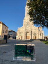
Measurement_633f4df7-fb71-49fb-998b-6d0cdab800b2

Measured radiation

0.268 µSv/h
geolocalisation :

9.6052145, 77.1719717

Ground level
ghis
ATYPICAL MEASURE
Date de la mesure :
Latitude :
9.6052145
Longitude :
77.1719717
Altitude (M) :
779.0
Measurement time :
1 minutes 16 secondes
Distance travelled :
8.80m
Measurement speed :
Measurement Environment :
En ville city
Weather :
Tags :
Description :
Temperature :
22.0°C
Hits number :
51
Mesure UUID :
633f4df7-fb71-49fb-998b-6d0cdab800b2
Manual Reporting :
No
Sensor / ID :
88:4A:EA:7C:11:38
Sensor / Firmware version :
AtomTag v.1.0.3
Sensor / Type :
Sensor / Tube type :
SBM-20
Smartphone / UUID :
87e7ea330f6a93b0
Smartphone / Platform :
Android
Smartphone / Model :
DIG-L21HN
Smartphone / OS Version :
6.0
Position acurracy :
31.1
Measurement height above the ground (in meters) :
1.00
Altitude accuracy :
31.1
Mean qualification :
Ground level
Software version :
OpenRadiation app 2.1.0
Measured value :
0.268 µSv/h

Measurement_7e971779-d53d-4c39-8fd9-2c69be5b5629

Measured radiation

0.156 µSv/h
geolocalisation :

47.1526783, -1.5236451

Ground level
amorel
Date de la mesure :
Latitude :
47.1526783
Longitude :
-1.5236451
Altitude (M) :
67.0
Measurement time :
2 minutes 18 secondes
Distance travelled :
0.00m
Measurement speed :
Measurement Environment :
En ville city
Weather :
Tags :
Description :
Temperature :
22.0°C
Hits number :
74
Mesure UUID :
7e971779-d53d-4c39-8fd9-2c69be5b5629
Manual Reporting :
No
Sensor / ID :
000107
Sensor / Firmware version :
OG-KIT1
Sensor / Type :
Sensor / Tube type :
SBM-20
Smartphone / UUID :
82e157ee5e58f63e
Smartphone / Platform :
android
Smartphone / Model :
21081111RG
Smartphone / OS Version :
14
Position acurracy :
6.3
Measurement height above the ground (in meters) :
1.00
Altitude accuracy :
6.3
Mean qualification :
Ground level
Software version :
OpenRadiation app 3.0
Measured value :
0.156 µSv/h

Measurement_4eba536e-cf85-4a88-9f2b-e7ddbea7fe6b

Measured radiation

0.090 µSv/h
geolocalisation :

47.3624821, 5.0197886

Ground level
suzon-21
Date de la mesure :
Latitude :
47.3624821
Longitude :
5.0197886
Altitude (M) :
329.0
Measurement time :
5 minutes
Distance travelled :
0.00m
Measurement speed :
Measurement Environment :
En ville city
Weather :
Tags :
Description :
compteur br-9b tube j 321
Temperature :
Hits number :
Mesure UUID :
4eba536e-cf85-4a88-9f2b-e7ddbea7fe6b
Manual Reporting :
Yes
Sensor / ID :
Sensor / Firmware version :
Sensor / Type :
Sensor / Tube type :
Smartphone / UUID :
02748f5609387157
Smartphone / Platform :
Android
Smartphone / Model :
ARCHOS T96 3G_EEA
Smartphone / OS Version :
11
Position acurracy :
2500.0
Measurement height above the ground (in meters) :
1.00
Altitude accuracy :
2500.0
Mean qualification :
Ground level
Software version :
OpenRadiation app 2.3.5
Measured value :
0.090 µSv/h

Measurement_cdf720dd-3c1b-4e10-a281-b1ff2c42f2e9

Measured radiation

0.066 µSv/h
geolocalisation :

44.557687857272, 6.0772508272643

Ground level
Yann29
Date de la mesure :
Latitude :
44.557687857272
Longitude :
6.0772508272644
Altitude (M) :
732.0
Measurement time :
3 minutes 35 secondes
Distance travelled :
0.00m
Measurement speed :
Measurement Environment :
En ville city
Weather :
Tags :
Description :
measurment image
Temperature :
24.0°C
Hits number :
52
Mesure UUID :
cdf720dd-3c1b-4e10-a281-b1ff2c42f2e9
Manual Reporting :
No
Sensor / ID :
Sensor / Firmware version :
OpengKIT72
Sensor / Type :
Sensor / Tube type :
Smartphone / UUID :
BD2C896C-CF53-4C23-B10A-A484AFB22EE2
Smartphone / Platform :
ios
Smartphone / Model :
iPhone14,4
Smartphone / OS Version :
17.6.1
Position acurracy :
4.7
Measurement height above the ground (in meters) :
0.00
Altitude accuracy :
4.7
Mean qualification :
Ground level
Software version :
OpenRadiation app 3.0
Measured value :
0.066 µSv/h

Measurement_75ecf5e8-8469-4bb0-a393-e90c6641b512

Measured radiation

0.340 µSv/h
geolocalisation :

50.3944497, 3.4834515

Ground level
Glenn Guihard
ATYPICAL MEASURE
Date de la mesure :
Latitude :
50.3944497
Longitude :
3.4834515
Altitude (M) :
Measurement time :
Distance travelled :
0.00m
Measurement speed :
Measurement Environment :
En ville city
Weather :
Tags :
Description :
Temperature :
23.0°C
Hits number :
Mesure UUID :
75ecf5e8-8469-4bb0-a393-e90c6641b512
Manual Reporting :
Yes
Sensor / ID :
Sensor / Firmware version :
Sensor / Type :
Sensor / Tube type :
Smartphone / UUID :
46c38c67530fe302
Smartphone / Platform :
Android
Smartphone / Model :
M2006C3LG
Smartphone / OS Version :
10
Position acurracy :
1500.0
Measurement height above the ground (in meters) :
1.00
Altitude accuracy :
1500.0
Mean qualification :
Ground level
Software version :
OpenRadiation app 2.3.4
Measured value :
0.340 µSv/h

Measurement_bbdff02b-8e36-4cd4-a515-995523c6c780

Measured radiation

0.218 µSv/h
geolocalisation :

44.560327302818, 6.0808592376047

Ground level
Yann29
ATYPICAL MEASURE
Date de la mesure :
Latitude :
44.560327302818
Longitude :
6.0808592376047
Altitude (M) :
736.0
Measurement time :
1 minutes 42 secondes
Distance travelled :
27.61m
Measurement speed :
Measurement Environment :
En ville city
Weather :
Tags :
Description :
Temperature :
25.0°C
Hits number :
58
Mesure UUID :
bbdff02b-8e36-4cd4-a515-995523c6c780
Manual Reporting :
No
Sensor / ID :
Sensor / Firmware version :
OpengKIT72
Sensor / Type :
Sensor / Tube type :
Smartphone / UUID :
BD2C896C-CF53-4C23-B10A-A484AFB22EE2
Smartphone / Platform :
ios
Smartphone / Model :
iPhone14,4
Smartphone / OS Version :
17.6.1
Position acurracy :
35.0
Measurement height above the ground (in meters) :
0.00
Altitude accuracy :
35.0
Mean qualification :
Ground level
Software version :
OpenRadiation app 3.0
Measured value :
0.218 µSv/h

Measurement_ff5366d7-c4fc-42dd-a3db-e71693063711

Measured radiation

0.075 µSv/h
geolocalisation :

45.556271666667, -73.6407

Ground level
Fanche
Date de la mesure :
Latitude :
45.556271666667
Longitude :
-73.6407
Altitude (M) :
621.0
Measurement time :
1 minutes
Distance travelled :
5216.15m
Measurement speed :
Measurement Environment :
En ville city
Weather :
Tags :
Description :
Temperature :
Hits number :
25
Mesure UUID :
ff5366d7-c4fc-42dd-a3db-e71693063711
Manual Reporting :
No
Sensor / ID :
safecast_id 3220
Sensor / Firmware version :
$BNRDD
Sensor / Type :
Sensor / Tube type :
Smartphone / UUID :
Smartphone / Platform :
Smartphone / Model :
Smartphone / OS Version :
Position acurracy :
9.0
Measurement height above the ground (in meters) :
1.00
Altitude accuracy :
9.0
Mean qualification :
Ground level
Software version :
openradiation.net/upload v0.9
Measured value :
0.075 µSv/h

Measurement_ff7eb7ec-5508-4e03-aab0-471708014698

Measured radiation

0.093 µSv/h
geolocalisation :

41.377586666667, 2.1837766666667

Ground level
Fanche
Date de la mesure :
Latitude :
41.377586666667
Longitude :
2.1837766666667
Altitude (M) :
3.0
Measurement time :
1 minutes
Distance travelled :
66.89m
Measurement speed :
Measurement Environment :
En ville city
Weather :
Tags :
Description :
Temperature :
Hits number :
31
Mesure UUID :
ff7eb7ec-5508-4e03-aab0-471708014698
Manual Reporting :
No
Sensor / ID :
safecast_id 1225
Sensor / Firmware version :
$BNRDD
Sensor / Type :
Sensor / Tube type :
Smartphone / UUID :
Smartphone / Platform :
Smartphone / Model :
Smartphone / OS Version :
Position acurracy :
8.0
Measurement height above the ground (in meters) :
1.00
Altitude accuracy :
8.0
Mean qualification :
Ground level
Software version :
openradiation.net/upload v0.9
Measured value :
0.093 µSv/h

Measurement_ff7eb7ec-5508-4e03-aab0-471708017794

Measured radiation

0.126 µSv/h
geolocalisation :

41.372563333333, 2.1892733333333

Ground level
Fanche
Date de la mesure :
Latitude :
41.372563333333
Longitude :
2.1892733333333
Altitude (M) :
4.0
Measurement time :
1 minutes
Distance travelled :
62.48m
Measurement speed :
Measurement Environment :
En ville city
Weather :
Tags :
Description :
Temperature :
Hits number :
42
Mesure UUID :
ff7eb7ec-5508-4e03-aab0-471708017794
Manual Reporting :
No
Sensor / ID :
safecast_id 1225
Sensor / Firmware version :
$BNRDD
Sensor / Type :
Sensor / Tube type :
Smartphone / UUID :
Smartphone / Platform :
Smartphone / Model :
Smartphone / OS Version :
Position acurracy :
8.0
Measurement height above the ground (in meters) :
1.00
Altitude accuracy :
8.0
Mean qualification :
Ground level
Software version :
openradiation.net/upload v0.9
Measured value :
0.126 µSv/h